The weather will be perfect for this year’s Shore Sweep — 75 degrees and sunny.
The folks from the Lake Lanier Association need help scouting out the shoreline in advance of the big day, Saturday, September 28th.
If you are available to drive your boat around one day this week, scout the shoreline and mark the locations on a map, that would be very helpful in planning how to deploy Shore Sweep volunteers. If you are available to scout, please email: [email protected].
As my mother used to say, “Many hands make light work!” Put your hands to work for a great cause — cleaning the junk out of Lake Lanier — for a few hours.
Shore Sweep starts at 8:00 AM and finishes up around 1:00 PM. You do not need to preregister to help out. Garbage bags and gloves will be provided. Just wear clothes that you won’t mind getting dirty or wet, please.
On Saturday, trash can be taken to these marinas:
- Bald Ridge
- Habersham
- Lanier Harbor
- Holiday
- Aqualand
- Sunrise Cove
- Gainesville and
- Port Royale Marina.
Three parks will also be drop-off zones for Shore Sweep:
- Lake Lanier Islands
- Clarks Bridge and
- War Hill Park.
Organizers are taking your trash early too. The advance locations will only accept stuff taken from the lake until Friday evening, September 27th — while the Shore Sweep signs are showing! Please do not bring your junk there at any other time.
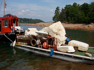
Bring bagged trash or large items and leave them at one of these locations. We have volunteers with boats scheduled to pick up at all these locations on Saturday morning for removal. This is a great way to contribute to this event if your schedule won’t allow you to be there on Saturday.
Please leave lake debris close to the signs.
Advance Shore Sweep Locations
These lake map coordinates are from the Atlantic Mapping Recreation and Fishing Guide for Lake Lanier.
- Map coordinate J-12, buoy marker 1SM, beach at Shady Grove Park
- Map coordinate H-7, Beaver Ruin Road shoreline area
- Map coordinate N-4, Lanier Harbor Marina
- Map coordinate N-9, buoy 14, Gaines Ferry Islands
- Map coordinate L-18, buoy 33, Keith’s Bridge Island
- Map coordinate M-24, Old Dawsonville Highway road bed near DNR regional office and Martin Docks
- Map coordinate M-28, buoy 2WC, unnamed island
- Map coordinate D-21, buoy 21C, Nix Island