
Lake Lanier’s water level hit 1073.23 above sea level at 8 AM on May 30, 2018. Rain from the storm named Alberto is still falling and much more water will soon drain into Lanier. The US Army Corps of Engineers (USACE) says closures on Lake Lanier are taking place, with more to come.
This message was posted on the Lake Lanier USACE Facebook page on May 30th:
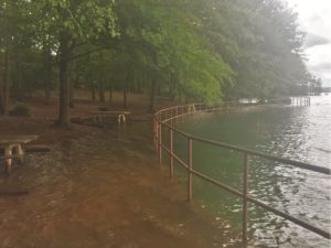
HIGH LAKE LEVEL CLOSURES:
Due to the lake level rising above 1073 MSL, the following closures will be applied:
- The walking path at West Bank (pictured) will be flagged off and closed.
- Nix Bridge boat ramp closed.
- Thompson Creek boat ramp closed
“Full pool” is the ideal level for the lake. We are 2.23 feet above that mark. Lanier is now more than two feet higher than at any time in April, and continues to rise.
We haven’t seen water levels this high since December of 2015, when the lake averaged 1073.47 for the entire month.
Check Lanier’s Historic Levels Here
Additional water increases will close additional boat ramps. If you are skilled in Excel spreadsheets, you may download a file named “Ramp & Bridge Elevations” by clicking here.
It was created so that you can input the current lake level to determine which ramps close as levels change, but that function doesn’t work. You can, however, observe the lake elevation at which various boat ramps must be closed.


