Laurel Ridge Trail
This easy walk follows the ridge line east of Lake Lanier dam for 3.8 miles.
Along the way are a number of facilities including bathrooms, water fountains, swimming areas, scenic vistas and boat ramps, making this an excellent family hike. Our mileage differs from other sources because we include exploring Lanier Dam Park. .
Start
Beginning at the Lower Overlook between a rest room and Highway 20, the pathway bears left shortly after the end of the building across a small valley, then makes a brief climb to the road. Cross at the marked intersection and be careful as motorists in the area exceed the speed limit. As the path moves away from Buford Dam Road an intricate brown metal structure prohibits motorized vehicles, while permitting hikers.
As with so many of these hiking walks in the Lake Lanier area, dogs are not permitted. The trail begins an easy descent, making a hard right into the first picnic area, skirting rest rooms on the left. Benches occasionally line the trail as it begins its descent into the Chattahoochee River Valley. At times during the descent the trail becomes hard to navigate thanks to tree roots and embedded rocks.
Great Views
At .1 miles a viewing platform to the right has some good winter vistas. Return to the trail and continue the extended descent. At .4 miles there is an overlook with an excellent year-round view of Bowman’s Island Unit. First of the parks in the Chattahoochee National Recreation Area, Bowman’s Island encompasses the area beneath the dam that creates Lake Lanier. About 200 feet past a wooden walkway a trail on the right leads onto a wooden walkway that forms the entrance to Bowman’s Island.
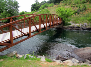
The trail follows the level, river birch lined east bank of the Chattahoochee River south. In .3 miles turn on the trail to the left, which crosses a small flood plain then begins a moderate to difficult rise out of the Chattahoochee River Valley, climbing along the banks of a tributary of the mighty Chattahoochee River. The trail crosses the tributary a number of times, usually on a wooden bridge, but in one spot a boulder provides an easy crossing. There is a bench on a wooden bridge that allows a peaceful moment watching the tributary flow easily down a near vertical wall.
As the ascent moderates the trail passes through a set of stone pillars, crosses busy Buford Dam Road and continues on the side through a set of the same stone pillars. During this short portion you are in full sun. After passing through the second set of stone pillars the trail quickly returns to the forest and is mostly to fully shaded.
The halfway point in the hike is a powerline clearing at 2.4 miles. In full sun for about 0.1 mile, the trail winds through the open field as it descends at a fairly rapid rate. At the end of the clearing the path curves to the left, drops down a set of steps, crosses a land bridge, then makes a sharp right-hand turn.
Turning for Home
At 2.7 miles the Laurel Ridge Trail crosses two park access roads. Less than 0.1 mile later is a small playground quickly followed by a pavilion with picnic tables and a grill, water spigot, garbage pails and rest rooms. In full sun, the trail follows a sidewalk, descending a set of steps and making a hard left-hand turn at the bottom. To get around a shelter, the path turns right, then left, returning to compacted soil. Look for a white blaze and brown hiker sign almost straight ahead to find the correct trail. Quickly, the path begins a descent to the first view of Lake Lanier since the start of the trail.
The trail makes a hard left turn, but continue on, bearing to the right to an overlook. Return to the Laurel Ridge Trail, turning right and bearing right on the white-blazed trail. Almost immediately the trail crosses a finger of Lake Lanier on a boardwalk, continuing to another overlook of Lanier. The path takes on a repetitive nature at this point.
Maps might be nice…